River Fire is fully contained
MONTEREY COUNTY, Calif. (KION)
UPDATE 9/4/2020 7:00 p.m. - The River Fire is 100% contained, nearly three weeks after sparking during the July 16th lightning storm.
In all, the fire burned 48,088 acres - leading to evacuations for thousands of people in communities along River Road and as far south as Greenfield.
13 structures were damaged, 30 were destroyed.
- 11 single family residences damaged
- 13 single family residences destroyed
Monterey County fire assistance information here.
UPDATE 9/2/2020 6:30 p.m. The River Fire is still at 48,088 acres, but containment is up to 98%.
UPDATE 9/1/2020 6:15 p.m. The River Fire is still 48,088 acres, but containment has grown to 97%.
UPDATE 8/31/2020 6:45 p.m. The River Fire is still 48,088 acres, but containment has grown to 96%. 13 structures were damaged by the fire and 30 were destroyed.
UPDATE 8/31/20 7:00 a.m. The River Fire is at 48,088 acres with 95% containment.
UPDATE 8/30/2020 7:30 p.m. Containment has risen to 93% as of Sunday night. The fire has burned 48,088 acres, the same number it was on Saturday.
UPDATE 8/29/2020 7:30 p.m. Containment has risen to 83% as of Saturday night. The fire has burned 48,088 acres.
All evacuation warnings and orders have been lifted.
Cal Fire says: "Firefighting efforts along with improved weather conditions continue to reduce fire activity. Firefighting crews continue to patrol and mop up inside the fire’s perimeter. Fire personnel resources are beginning to return to their respected Units or reassigned to other incidents."
Expected full containment is on Sept. 6, 2020.
UPDATE 8/28/20 7:00 a.m.- Containment has risen to 66 percent as acreage holds steady at 48,732.
UPDATE 8/27/20 6:50 p.m. - Containment once against rises for the River Fire south of Salinas, with no change in growth.
The fire has burned 48,732 acres. Containment is 63 percent. Cal Fire's Thursday night update says:
"Infrared Technology is being utilized to assist with detecting hidden fire and hot spots. This technology is assisting ground resources with locating hidden hot spots not seen to the eye. Firefighting crews keep working on reinforcing containment lines along Arroyo Seco Road."
Thursday morning, all River Fire evacuations orders and warnings were lifted.
Residents can visit "commodity point of distribution" sites for things like comfort kits, Personal Protective Equipment and bottled water.
They are set up at :
- Greenfield Memorial Hall, 615 El Camino Real, Greenfield
- Carmel Valley Village near the Chevron Station
- The intersection of Tassajara and Carmel Valley Roads
- Open 8:00am – 4:00pm through Friday, August 28th
UPDATE 8/27/20: The River Fire has grown to 48,732 acres and remains 58% contained.
181 structures are still threatened.
UPDATE 8/26/2020 7:15 p.m. The River Fire has still not grown past 48,424 acres, but it is now up to 58% contained.
Cal Fire said the fire has line nearly all the way about it, but they still have people patrolling to look for hot spots, answer calls for service and mop up.
More evacuation orders and warnings were lifted Wednesday in Monterey County, and they expect more in the next day or two.
Damage inspection have been finished, and a total of 13 structures were damaged and 30 were destroyed.
The fire is expected to be fully contained by Sept. 6.
UPDATE: 8/26/20 8:00 a.m. 48,424 acres have burned and containment is at 48% .
Expected Full Containment is 9/06/2020.
UPDATE: 8/25/20 7:50 p.m.
Progress was made on the River Fire Tuesday, as the size of the fire remained the same, but containment grew to 43%.
"Marine layer from last night allowed the relative humidity to return to 50-60% and allowed firefighters to make great progress by reinforcing containment lines and repopulating more zones," Cal Fire wrote in their Tuesday night update.
While there has been success fighting the fire, more structures are being reported as damaged and destroyed.
With 90% of the damage assessment completed:
- Single Residences: 6 Damaged, 50 Destroyed
- Other Minor Structures: 1 Damaged, 23 Destroyed
Cal Fire says they are working to put out smoldering inside of the containment lines. Smoke is expected to be visible by River Road, near Limekiln.
UPDATE 8/25/2020 12 p.m. The River Fire is now a third of the way contained, according to the Monterey County Office of Emergency Services.
The fire has stayed at 48,424 acres and is now 33% contained.
UPDATE 8/24/2020 7:20 p.m. The River Fire burning south of Salinas has not grown in acreage Monday, but it has grown in containment.
The fire is currently 48,424 acres and is 28% contained. Cal Fire said the fire is currently only burning within containment lines, but there will continue to be some smoke as large fuels continue to smolder.
The fire is most active in the southern end near a truck train in a rural area, according to officials.
Many evacuations on the north end of the fire were lifted Monday, and thousands of people were able to return home. Sheriff Steve Bernal said more orders will be lifted when it is safe to do so, but they cannot give specific dates yet.
He thanked everyone for their cooperation and said law enforcement is still patrolling areas under evacuation.
.@CALFIREBEU 08.23.20 19:00hr Incident Briefing https://t.co/gMJMeEyFv8
— CAL FIRE BEU (@CALFIREBEU) August 24, 2020
UPDATE 8/23/20 - 7:15 p.m. The fire remains at 48,424 acres, however containment increased to 20%.
- 1274 personnel assigned (compared to 967 on Friday)
- 8 residences damaged, 8 destroyed
- Damage inspection is 50 percent complete
"The fire continues to burn interior pockets of vegetation and is smolder around structures. The cloud cover along with increased humidity has helped firefighters make progress on the fire by slowing the fire spread," Cal Fire reports Sunday night.
Update 8/23/20 - 11:00 a.m.
Cal Fire officials announced Sunday morning that the River Fire has reached 48,424 acres. Containment remained at 15%.
Officials say the River fire could merge with the Carmel Fire if it moves too far south when the winds move to the southeast flow.
A red flag warning went into effect Sunday at 5 a.m. and is expected to last until Monday at 5. p.m. for dry lightning and erratic gusty winds of up to. 65 mph.
Please watch our most up to date Operational Briefing for #RiverFire and #CarmelFire by clicking on the link below.https://t.co/bvYsayk3pv
— CAL FIRE BEU (@CALFIREBEU) August 23, 2020
19 structures have been destroyed and 8 have been damaged.
Officials expect the fire to be fully contained by Sept. 6.
#RiverFire 8.23.20 AM update
— CAL FIRE BEU (@CALFIREBEU) August 23, 2020
Location: South of Salinas (Monterey Co.)
Acres: 48,424
Containment: 15% pic.twitter.com/tEZm4fC0IJ
UPDATE 8/22/20 7 p.m.
Cal Fire officials reported the River Fire has reached 47,773 acres by Saturday evening. Containment has increased to 15%.
Cal Fire shared current operations and preparations for the rest of the weekend's battle during a press conference.
Cal Fire says wind is a big concern Sunday and could test lines that have been laid. Firefighters were able to increase containment and make some progress Saturday.
Cal Fire says firefighters are mopping up near the River fire and working on getting control lines. The fire is moving southwest.
Monterey County Sheriff Steve Bernal said areas south of Laureles grade were evacuated Saturday. Theses areas were placed on evacuation orders beginning Saturday.
11 structures have been destroyed, thousands remain threatened by the fire. CalFire is a third of the way through damage inspection and those numbers may get higher.
43,761 people are under either an evacuation order or warning.
Due to unpredictable weather forecasted for the coming days, Sheriff Bernal says things could change at any time. Because of this, residents should be packed and ready to go at a moment's notice.
New evacuation orders issued for the Carmel and River fires:
- All areas east of Carmel Valley Road, south from Finch Creek to Arroyo Seco Road
- All areas west of River Road/Fort Romie Road/Arroyo Seco Road extending south to Elm Ave/Arroyo Seco Road
Cal Fire said, at this time, the River Fire is not considered a threat to the City of Soledad.
Firefighters will be receiving funds from the federal government as part of the major disaster declaration.
UPDATE 8/22/20 11:00 a.m. Cal Fire provided updates on the Carmel and Rivers fire during a press conference on Saturday.
Officials warned of a Red Flag warning that is set to go into effect at 5 a.m. Sunday and remain in place until 5 p.m. Monday. The Red Flag warning brings the risk of windy conditions and additional lightning strikes that could hamper firefighting efforts.
The Monterey County Sheriff's Office also provided updates on new evacuation orders and warnings for these fires.
For the latest evacuation warnings and orders, click here.
UPDATE 8/22/20 8:00 a.m. The acreage burned in the River Fire inched up on Saturday morning to 44,987 acres. According to Cal Fire rolling materials, steep terrain and spot fires continue to pose a threat to surrounding communities.
8 structures have been damaged in the fire so far.
The weather might also pose a problem. A low-pressure system is moving up the coast of California bringing a shift in wind patterns from the northwest to the southeast. Officials ask you to stay alert for any changes in evacuation warnings and orders.
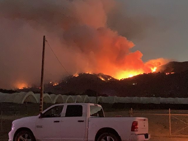
UPDATE 8/21/2020 7:30 p.m. Cal Fire said in a press conference Friday that the River Fire has grown to 42,583 and is 12% contained.
This weekend, crews are expecting a weather change and a change in wind direction, which could be favorable, but there is also the possibility of a dry lightning storm. A dry lightning storm Sunday is what initially sparked the River Fire
Officials said the fire did not spread much during the day, but it has tended to be most active in the afternoon. They say it is possible that the River Fire could connect with the Carmel Fire, but so far they are holding.
The area between Corral de Tierra and Laureles Grade was put under an evacuation warning Friday as a precaution ahead of the weekend. To allow people to evacuate without traffic, the Monterey County Sheriff's Office is asking people to avoid the Monterey Bay and Carmel areas, especially around Highway 68 and Carmel Valley Road.
Thursday night, the fire went into Toro Park, but Cal Fire said it did not cross Highway 68.
UPDATE 8/21/2020: Cal Fire says the River Fire has grown to 39,464 acres and is 9% contained.
Officials say a spot fire on the northern side of the fire grew rapidly with a strong west wind increasing threat to structures in multiple major housing developments. Winds increased fire activity on the southeast portion of the fire, impacting public safety communications and television infrastructure.
UPDATE 8/20/2020 7:45 p.m. River Road between Highway 68 and Chualar River Road is closed, according to the Monterey County Sheriff's Office.
Sheriff Bernal said the closure is an effort to allow crews to move freely. They are also asking people to stay away from fire lines for their own safety and for the safety of responders. If conditions allow, Bernal said the road and some evacuations may lift tomorrow.
Cal Fire officials said 10 structures were destroyed in the River Fire, and two were damaged.
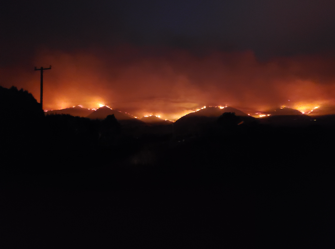
Cal Fire said the fire was especially active on the northern end Thursday, particularly around Berry Road and Pine Canyon Road.
The base camp at Toro Park is still open, but non-essential personnel have been moved.
The fire has burned 33,974 acres and is 9% contained.
UPDATE 8/20/20: The River Fire burning south of Salinas has grown to 33,653 acres, and it is still only 7% contained.
UPDATE 8/19/2020 10:36 p.m. The River Fire burning south of Salinas and toward Gonzales has grown to 15,050 acres, and it is still only 7% contained.
Sheriff Bernal said several thousand people were evacuated from their homes along River Road today, and he said he has seen people coming from out of town to look at the fire. Bernal asks that people stay off River Road whenever possible to allow crews and residents to access the area.
Cal Fire said the fire is 1.8 miles from the Carmel Fire, so crews do not expect that the fires will merge.
At around 10 p.m., officials called for the evacuation of all areas of San Benancio Rd between Troy Ln and Coral De Cielo Rd.
They said no evacuations are expected on the Monterey peninsula.
UPDATE 8/19/2020 5:30 p.m. It was a different scene during the day on Wednesday than it was the night before where the River Fire more than doubled in size in just a matter of hours.
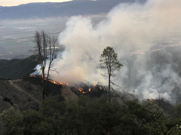
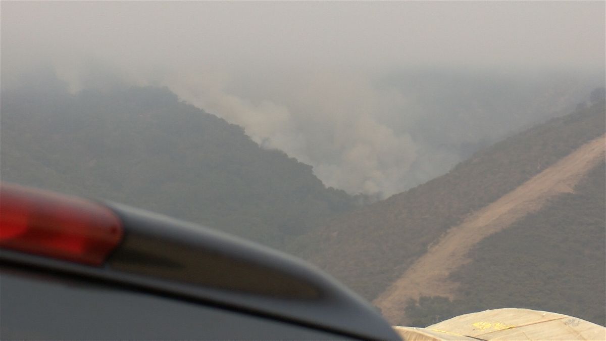
Vegetation along the hills could still be seen smoldering and burning more smoke into the air on Wednesday. Firefighters say the flames were able to get into a highly flammable area and then just ride the landscape south eastward, now burning nearly 11,000 acres.
Crews spent the morning prepping to work on those new hot zones while also providing structure defenses as well. There is also talk about combining the River Fire and the new Carmel Fire, currently burning south of the River Fire, into a single operation, or complex.
"So what a complex is is when you have multiple fires in a given area, in kind of a close geographical area, rather than bringing in multiple management teams for each fire, we'll use one management team to manage multiple fires," said Capt. Daniel Bertucelli, the spokesman for the Incident Management Team for the River Fire.
Complexing the two fires, as it is called, is still in the discussion stages. On Wednesday, crews will make sure everyone who needs to evacuate has done so, protect homes and keep the fire at bay.
UPDATE 8/19/2020 11:15 a.m. New evacuation orders are in place for Las Palmas Parkway, Ranchito Drive, Indian Springs Road, Berry Drive, Enos Drive, Redding Drive and Belmont Circle.
UPDATE 8/19/2020 10:45 a.m. Evacuation warnings have extended to include areas north of Highway 68 from San Benancio Road east to include all roads off Portola Drive to Veronica Drive.
Officials just issued evacuation orders for all areas south of Highway 68 on San Benancio Road to Harper Road.
UPDATE 8/19/2020 10:30 a.m. The Monterey County Office of Emergency Services has extended its evacuation orders to include all areas south of Highway 68 on San Benancio Road to Harper Canyon road.
Residents are being told to leave the area immediately.
UPDATE: The Monterey County Sheriff's Office has changed the Evacuation Warning to an Evacuation Order for the following areas: Communities within the north of San Benancio Rd, West of Troy Lane, Southeast of Harper Canyon Rd to include Harper Canyon Road, Weather Rock Way, Rimrock Canyon Road. Leave the area immediately. Evacuate north on San Benancio Rd to Highway 68.
UPDATE 8/19/20: The River Fire in Salinas has grown to over 10,000 acres overnight.
It's just 7 percent contained.
Firefighters continue to aggressively engage in firefighting efforts, but mountainous, steep terrain and difficult access has been challenge.
Hot, dry weather and absence of marine layer has made vegetation more receptive and has resulted in increased fire intensity and rates of spread and longer burn periods. The fire progressed significantly to the southeast towards the valley.
Motorists should drive cautiously and always yield to emergency vehicles that are traveling on and off roads and highways. Fire danger remains elevated and everyone should continue to use extreme caution and refrain from daily activities that may spark a wildfire.
UPDATE 8/18/2020 10:43 p.m. Cal Fire and other agencies provided an update on the River Fire Tuesday, saying that it has grown to 4,509 acres, but containment has dropped to seven percent.
According to Cal Fire, 1,527 structures are threatened, six have been destroyed and two have been damaged.
Officials said the fire was active Tuesday and burned both to the north and south. It was especially active near River Road and Limekiln, but said it has made no significant runs toward Salinas or Highway 68. Cal Fire officials said they are bringing the fire south, to the "target area of opportunity."
Video and photos coming in to the newsroom show the fire is spreading south rapidly and can be seen from Gonzales.
As the fire moves south, they have added a new evacuation order.
- Parker Road South to Limekiln Road.
- West of River Road from Limekiln Road to Gonzales River Road
The Monterey County Sheriff's Office said it has 32 people helping with the evacuation of 5,039 people. There are two officers from Marina, two from CSUMB and two from Del Rey Oaks assisting.
UPDATE: 8/18/20 7:00 A.M.- 4,070 acres have now been burned in the River Fire and it is 10% contained this morning.
1,527 structures are threatened and firefighters from all over the state are working aggressively to get it under control.
The hope is to have the fire fully contained by August 30th.
Officials say motorists should drive cautiously and always yield to emergency vehicles that are traveling on and off roads and highways. Fire danger remains elevated and everyone should continue to use extreme caution and refrain from daily activities that may spark a wildfire.
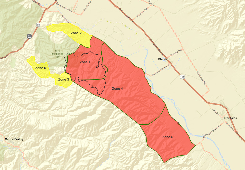
UPDATE: 8/17/20 2:15 P.M. - New evacuations warnings have been issued for the River Fire. Communities:
- North of San Benancio Road, West of Troy Lane, Southeast of Harper Canyon Road to include Harper Canyon Road Weather Rock Way, Rimrock Canyon Road
Mandatory evacuation order remains in effect for:
- Pine Canyon Road
- Parker Road
- Laurel Lane
- Trimble Hill Lane
UPDATE: 8/17/20 11:50 a.m. An evacuation warning has been issued Southwest of Parker Road, Northwest of Coral De Cielo Road and Rana Creek, Southeast of the intersection of Chualar River Road and River Road, Northwest of Limekiln Road/Creek.
The Monterey County Sheriff's Office has issued an advisory evacuation notice of Las Palmas 2 and Indian Springs Road.
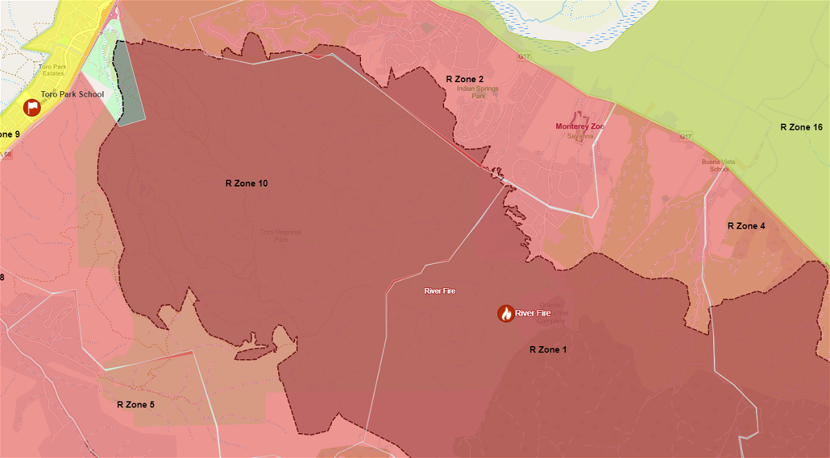
A spokesperson for Monterey County has also announced that Toro Park is closed to the public until further notice.
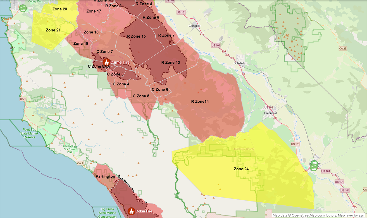
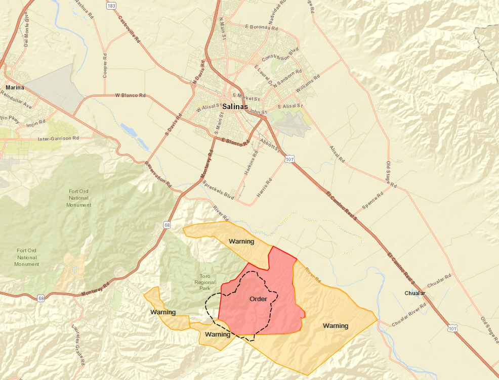
River Fire Evacuation Map from Monterey County
The park is being set up for use by CAL FIRE as its Incident Command for the River Fire.
UPDATE 8/17/20 6:00 a.m: The River Fire in Monterey County has grown to 2,800 acres and it still just 10 percent contained.
1,500 structures are now threatened as the fire continues to spread.
The fire has moved across Pine Canyon, continuing to move south toward River Road.
Mandatory evacuation orders are still in place for Pine Canyon Rd, Parker Rd, Laurel Ln & Trimble Hill Ln.
Evacuation advisories are in place for Indian Canyon, Mt. Toro Access Rd & San Benancio Rd from Troy Lane to Corral de Tierra.
Those who need a safe place for their livestock can take them to the Marina Equestrian Center, where dozens of horses are already being housed safely.
The SPCA Monterey County has set up a number to call if you need help with your animals. It's 831-264-5455.
--------------------------------------------------------------------------------------------------------------
UPDATE 8/17/20 12:08 a.m. The Monterey County Sheriff's office said las Palmas and Indian Springs Road is under an advisory notice for possible evacuations.
The evacuation center at Buena Vista Middle School has closed Sunday night.
The center opened early Sunday evening. A Monterey County spokesperson said it hosted a small number of evacuees, providing a respite, water and snacks.
Should the center be needed again, it may be reopened.
UPDATE 8/16/20 8:58 p.m.:The Monterey County Sheriff's Office tells KION about 80 people have been evacuated as the River Fire continues to burn.
UPDATE 8/16/20 The River Fire has grown to 2,000 acres and is 10 percent contained as of 8:04 p.m.
CAL FIRE said 30 structures are threatened, 5 structures are damaged and 4 firefighters are injured.
UPDATE 8/16/20 7:25 p.m. Monterey County is opening an evacuation center for River Fire evacuees at Buena Vista Middle School located at 18250 Tara Drive.
The county said the evacuation center is still being set up, but school officials have already opened their facility to welcome evacuees.
The county said the center will be a place where people can come to get out of the heat, make plans or ask for additional services.
Face coverings and social distancing protocols will be required at the center.
The Carmel Valley Library branch center is now closed.
UPDATE: 8/16/20 6:25 p.m. The Monterey County Sheriff's Office says they are now making mandatory evacuation notices for all of of Pine Canyon Road and Parker Road.
Mandatory evacuations are in place for Berry Rd., Indian Springs Rd., Parker Rd., Laurel Ln., and Trimble hill Ln.
An evacuation advisory is still in place for Mt. Toro Access Rd. and San Benancio Rd. from Troy Ln. to Corral de Tierra, according to CAL FIRE.
CAL FIRE says the fire has grown to 500 acres and is 10 percent contained as of 6:00 p.m.
For those being evacuated, the sheriff's office said there is an evacuation center opening at Carmel Valley Library. The SPCA is opening for animal boarding. Masks are required at the evacuation center.
This is a developing story. Check back here for updates.
UPDATE: 8/16/20 3:07 P.M.
CAL FIRE has issued an evacuation advisory for Corral del Cielo Road and Mt. Toro Access Road.
The blaze, which is being called the River Fire, has burned 150 acres and is 20 percent contained. 30 structures are threatened.
Two fire fighters have sustained heat related injuries.
UPDATE: 8/16/20 11:00 a.m.
CAL FIRES has confirmed that there are no evacuations and that no structures are threatened.
MONTEREY COUNTY, Calif. (KION) CAL FIRE is battling a vegetation fire that broke out near Toro Park Sunday morning. It was sparked by a lightning strike.
CAL FIRE received reports of a fire at the top of Pine Canyon, located about five miles south of Salinas, at 3:14 a.m.
The fire was about one acre in size when responders arrived at the scene, and has grown to approximately 20 acres. It is currently 20 percent contained.
CAL FIRE remains on scene with the Monterey County Regional Fire District.
There are currently 140 firefighters, three fire crews, 13 fire engines, one tactical observation platform, four air tankers, two helicopters, two bulldozers and two water tankers tending to the fire.
The Unit Information Officer for the San Benito-Monterey Unit of CAL FIRE told KION that "fire fighters are making good progress" on the blaze.